Version History
Here you can find the changelog of FLY is FUN Aviation Navigation since it was posted on our website on 2014-06-13.
The latest version is 33.20 and it was updated on soft112.com on 01 April, 2024.
See below the changes in each version:
version 33.20
posted on 2024-03-25
Version 33.20
- Removed bug: when Logbook had a lot of entries, the app crashed when editing the entries.
Version 33.12
- Refactored Route summary
- Removed some bugs
version 33.12
posted on 2024-03-22
- Refactored Route summary
- Removed some bugs
version 33.00
posted on 2024-02-20
- Refactored Airspaces list, VHF list, Logbook list, Route list, Route edit, Route summary, Flight plan list, Nav item edit, Pilot list,
- Refactored Aircraft list
- Document picture viewer did not turn photos orientation using EXIF data
- Added internal PDF viewer used when you display PDF airport document. This can be turned to external PDF viewer in Preferences (General settings)
- When is Route edit opened, you can set wind to all route WPTs from METAR.
- A lot of small improvements
version 32.11
posted on 2024-01-24
- You can display bubble messages on top of the screen (Preferences, Screen settings / Display bubble message on top)
- You can choose to display the vertical view for portrait and landscape mode separately for map and terrain screens.
- Refactored VHF and Airspaces windows.
- The back key always meant to close the window. Now if the window contains a list the back key is used to "go up a level" and only if it can't, the window is closed. This option can be turned off in preferences.
version 32.05
posted on 2023-11-03
Version 32.05
- Removed bug: Open airport url crash
Version 32.04
- Removed bug at map screen: When you zoom in, sometimes vertical situation was not displayed (terrain and airspaces).
Version 32.02
- METAR and TAF data source change. The original one was suspended.
- Export / Import navigation database with folder's notes
- Removed bug: Notification icon was hidden at Android 13
version 32.04
posted on 2023-10-26
- Removed bug at map screen: When you zoom in, sometimes vertical situation was not displayed (terrain and airspaces).
- METAR and TAF data source change. The original one was suspended.
- Export / Import navigation database with folder's notes
- Removed bug: Notification icon was hidden at Android 13
version 32.02
posted on 2023-10-22
- METAR and TAF data source change. The original one was suspended.
- Export / Import navigation database with folder's notes
- Removed bug: Notification icon was hidden at Android 13
version 32.00
posted on 2023-10-01
- Navigation database has a new design. Route windows will follow.
- It is possible to control some FIF features by text file - Config.info. I will publish more information at http://www.funair.cz/forum/
- Removed minor bugs.
version 31.62
posted on 2023-08-26
Version 31.62
- Internal changes
Version 31.60
- New maps for Europe Top Plus Open. Menu / Downloads / Topographical maps
- Internal changes
- Unlocker is not used any more due to Google privacy policy
- Removed bug - When you tap TMA sometimes was shown TWR FRQ. Correct is APP or RDR.
version 31.60
posted on 2023-05-22
- New maps for Europe Top Plus Open. Menu / Downloads / Topographical maps
- Internal changes
- Unlocker is not used any more due to Google privacy policy
- Removed bug - When you tap TMA sometimes was shown TWR FRQ. Correct is APP or RDR.
version 31.52
posted on 2023-03-16
- Updated Russian and Spanish version. Thanks to Oleksandr and Rolando.
- Improved Select object dialog box.
version 30.04
posted on 2022-02-27
Removed bug - application did not work at new Samsung Galaxy S22
version 30.03
posted on 2022-01-12
Removed bugs - crash at some Lenovo devices when importing nav database
version 30.02
posted on 2021-12-18
Removed bud: At some devices crash when route editing
version 30.01
posted on 2021-12-15
- Removed bug: At Android 11 was not the unlocker visible.
- Back up your data to Google drive. Menu / App settings / Preferences - Data management
- ICAO NOTAM server API was changed.
- If you use Android 11 or higher, your data must be located in Android/Data/gps.ils.vor.glasscockpit/files. Sorry for it. It is Google restriction.
- Updated Czech, German, Polish, French, Italian, Slovenian and Spanish version. Thanks to Juergen, Krzystof, Antoine, Marco, Jernej an Rolando.
version 29.33
posted on 2021-12-11
- At some devices with Android version 11 was impossible to open PDF files.
- Updated Russian version. Thanks to Den
version 29.32
posted on 2021-10-24
Removed bug: When the data was placed at internal memory, it was impossible to upgrade the navigation database.
version 29.30
posted on 2021-10-15
- Data is moved to Android directory, because from November it must be - new Android rule.
- Updated Czech, German, Polish, French, Italian, Slovenian and Spanish version. Thanks to Antoine, Juergen, Krzystof, Marco, Jernej an Rolando.
version 29.20
posted on 2021-10-07
- LOG value box keeps last recorded time. You will not need to open Logbook to see the flying time.
- Removed bug: The application sometimes crashed when the Search button was pressed in the nav database list.
version 29.10
posted on 2021-08-31
Importing the world nav database: Now it is possible to select the previous AIRAC cycles.
version 29.01
posted on 2021-05-30
Version 29.01
- Improved METAR history charts (colors and added units)
- Possible quick switch-on/off displaying terrain at the map screen. Long tap AGL value window. You can still do it by long pressing compass rose and checking "Shows terrain".
version 29.00
posted on 2021-05-18
- Added METAR history chart. You can see how the weather developing at the chart. You can switch among the displayed values by swiping from left to right and vice versa. Open METARS, click at any one and select History.
- Removed bug: At some devices application did not show the last METARs and TAFs
version 28.70
posted on 2021-04-26
- Flight log XLS file contains RWYs at the airport WPTs (only raw data). Anyway you can create your own flight log template...
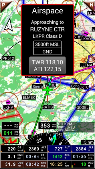
- When you tap the airspace, you can press the airspace name. This quickly opens the airspace list with selected airspace at the top.
- You can tag the airspace pattern. Tap a pattern and press the Tag button
- Removed bug: Manual GPS altitude correction was impossible to set.
version 28.51
posted on 2021-01-23
- Updated Russian and Spanish version. Thanks to Ден and Rolando.
- Removed some bug. Application at some crashed after launch.
version 28.32
posted on 2020-12-15
- METAR/TAF data server changed data structure so we implemented it.
version 28.30
posted on 2020-10-26
Version 28.30
- Refactored subscriptions. You can easy mage it. Preferences / General settings / Google play subscription
- Updated Czech, German, French, Italian, Polish and Slovenian version. Thanks to Antoine, Juergen, Marco, Krzystof and Jernej.
version 28.20
posted on 2020-10-19
Version 28.20
- Route export - added Garmin FPL format
- Removed bug: Some airports did not import when upgrading the world nav database
version 28.11
posted on 2020-09-10
- CRS line has triangle arrows. Inbound CRS part has yellow arrows, outbound one has orange arrows. You can switch it off at Screen customize, CRS color.
- If you tap map by two figers, info dialog box is displayed below vertical cut.
- Support for GDL90 GPS position - Menu / App settings / Preferences, External sources / WiFi / GDL90
- removed some bugs
version 28.01
posted on 2020-07-23
- Updated Czech, French, German, Italian, Polish, Slovenian and Spanish version. Thanks to Antoine, Juergen, Marco, Krzystof, Jernej and Rolando.
- Removed bug: Logbook edit and click on date/time from/to.
version 28.00
posted on 2020-06-30
- Refactored Aircraft
- Aircraft contains Weight and Balance.
- A lot of small improvements
version 27.31
posted on 2020-06-10
- Aircraft edit: new engine type: piston diesel
- Flight plan: If filled endurance is longer, then max aircraft possible endurance. it is red.
version 27.30
posted on 2020-06-02
- Route list: If the wind is defined for at least one leg of the route, the route row shows wind icon.
- Route edit: possible export Flight log (Menu, Share flight log). If the route has filled departure date / time, FIF fills ETA at route flight log (raw data).
- Removed bug: When route does not have selected aircraft, application did not fill active (default) aircraft.
- Removed bug: if METAR did not contain WX, it always displayed +SHRASNPL.
version 27.20
posted on 2020-05-18
- When planning the route, you can select the aircraft and departure time. Application shows for each route WPT: ETA, heading, ground speed, SR/SS calculated from departure time.
- Possible to set new wind during the flight to the active route (Menu/set wind).
- Possible to display new values at the main screen - FUEL (required fuel to NAV1 and required fuel to the end of route.
- Possible to hide decoded METAR data at METAR list (Menu/Other settings/Hide decoded data).
version 27.00
posted on 2020-05-03
- Optimized all main screens for screen aspect ratio 4:3, 10:6, 16:9 and long screens.
- Route edit design was a little bit changed.
- Possible displaying sunrise and sunset for last WPT of active route. If route is not active, sunrise or sunset is calculated to the naxt WPT (NAV1). Customize screen and select SS - End of route SS...
- Updated Slovenian and Spanish version. Thanks to Jernej and Rolando.
- A lot of small improvements
- Removed some bugs
version 26.81
posted on 2020-04-16
- Displayed VHF for airport patterns.
- If you display active route, coordinates of WPTs are hidden, radial and distance to nearest VOR, NDB is displayed.
- Route edit: You can set wind for all legs via menu (Manu / Set wind)
- Route edit: You can set altitudes for all legs via menu (Menu / Set altitudes). Altitude for each leg is calculated (desired minimum height over the highest leg point).
- Improved Density altitude calculator.
- METAR list displays the density altitude. You can hide it
version 26.71
posted on 2020-03-13
Version 26.71
- New METAR/TAF color scheme called FIF. This color scheme respects aviation VFR and IFR flight rules. Open METAR list, tap Menu / Color scheme and select FIF.
- Small improvements
Version 26.70
- Improved default / factory settings.
- improved Load default at map screen customizing (long press the compass rose, scroll down and press "Load default" button).
- Route list row displays now route name and also list of WPT names.
version 26.50
posted on 2020-03-01
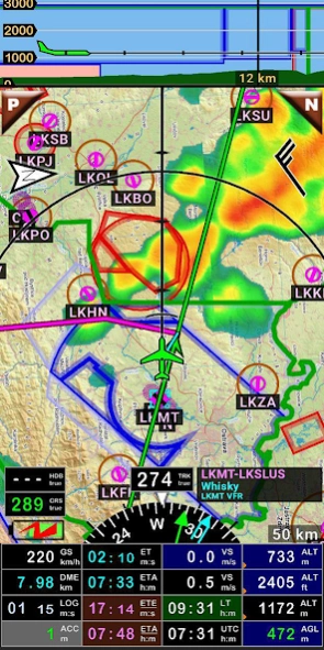
- METARs are displayed at the map. It is a circle with wind direction. Color of the circle is dependent of weather and selected color scheme. Color scheme is possible to set in Preferences or METAR list. The length of wind barb is dependent of wind.
- At the screen customizing you can also replace one of the screen values by selecting MTS - METAR / TAF switcher. Then you will see at the map screen if METARs are on/off and tap it for on/off.
version 26.43
posted on 2020-02-19
Version 26.43
- Updated Czech, German, French, Italian, Poland and Russian version. Thanks to Juergen, Antoine, Marco, Krzystof and Alex.
Version 26.42
- METAR and TAF weather is decoded. At this time English only. Translations will follow.
- You can select displaying sky coverage using icon or text (FEW, SCT, BKN...). At METAR list press Menu / Color scheme
- TAF has also color scheme (the same as METAR).
- Removed small bugs.
version 25.20
posted on 2020-01-20
- NOTAMs are accessible from Route List, Route Edit and active route.
version 25.10
posted on 2020-01-17
Version 25.10
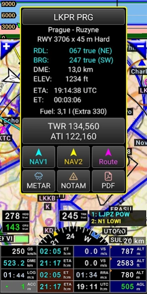
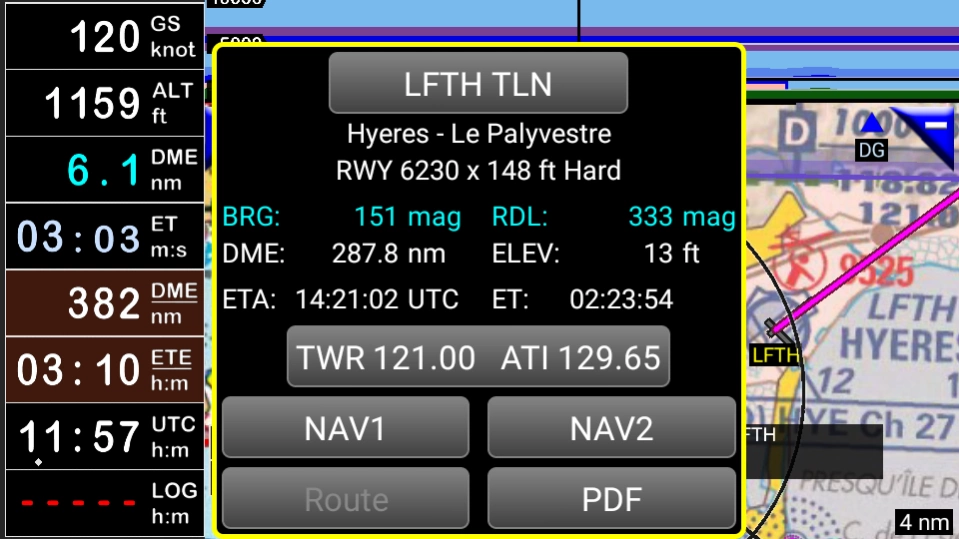
- Refactored info window (tap database object at the map). Added buttons NOTAM, METAR.
- Updated Czech, French, German, Italian, Poland and Spanish version. Thanks to Antoine, Juergen, Marco Krzystof and Rolando
version 25.01
posted on 2019-12-27
Version 25.00
- NOTAMs implemented (only the first part, I am still working on it).
- First you must inser NOTAM API key at the Preferences. Open Preferences (Menu/App settings/Preferences), find NOTAMs / Get API key.
- Open Nav item list, long press for desired airport and select NOTAM.
- Notams for route, distance range and map will follow soon.
version 24.31
posted on 2019-11-17
- Zoom up to 250 mn
- You can display age of ranfall radar data> Customize screen / select RRA }Rainfal Radar Age) at one of value window
- Refactored Position Info
- Heading bug is more visible
- Some lists at Android 10 was pink :-)
- Removed some minor bugs
version 24.21
posted on 2019-10-21
- Refactored searching in VHF list and Airspace list
- Application creates file name hint when exporting logbook
- Removed some minor bugs
version 24.20
posted on 2019-09-30
- Refactored creating nav database, added a lot of airports, runways and updated frequncies. Please update the nav database.
- Added button Source at Screen Customize / Rainfall radar. You can see the coverage of radars.
- Added possibility Direct to NAV1 and NAV2 by entering latitude and longitude - Menu/Navigate/Direct to (Coordinates).
version 24.10
posted on 2019-08-21
Version 24.10
- Internal changes for nav database import (airspaces)
- Updated German airspaces, thanks to Juergen
- Created cache for rainfall radar (much less internet downloading)
- Updated Czech, German and Poland version. Thanks to Juergen and Krzystof
version 24.02
posted on 2019-08-17
Version 24.02
- Displayed rainfall radar.
- Updated Russian version, thanks to Alex.
- Added VORTAC and TACAN to database - Database update necessary
- Easy displaying airspace from menu: Airspace list. Long tap at the airspace, select Show at the map centre
- Added support for wind. You can display wind and measure wind during the flight. If application knows wind, it is diplayed at the map screen.
version 23.10
posted on 2019-08-06
Version 23.10
- Added VORTAX and TACAN to database - Database update necessary
- Easy displayong airspace from menu: Airspace list. Long tap at the airspace, select Show at the map centre
Version 23.00
- Added support for wind. You can display wind and measure wind during the flight. If application knows wind, it is diplayed at the map screen. Menu / In flight settings / Wind or customize screen select value WD or WS and then if you tap it, you get the wind menu.
version 22.70
posted on 2019-07-17
Version 22.70
- Possible edit holding patterns (You can import IFR holding patterns when importing the world nav database)
- Easy creating holding patterns - Long tap map and then select Holding Pattern
- Updated Czech, French, German, Polish, Russian and Spanish version. Many thanks to Antoine, Juergen, Krzystof, Alex and Rolando.
- Removed crash? When long tap compass rose at Notepad screen.
- Removed bug: Exporting track from Logbook (KML format). Time was local, not Zulu time.
version 22.60
posted on 2019-07-08
- new 5th screen - Notepad (You can hide it in Preferences / Screen settings / Show/Hide screens]
version 20.26
posted on 2018-02-08
Version 20.26
- Updated PDF documents download
- Uploaded 60 countries for PDF download
Version 20.25
- Updated French and Russian versions. Thanks to Antoine and Alex.
- Available Czech user guide (Menu/Downloads/User guide)
version 19.23
posted on 2017-01-16
Version 19.23,- Updated Czech, German, France, Italian, Polish and Russian version. Thanks to Juergen, Antoine, Marco, Rolando, Krzystof and Alex.,- Removed bug when app launch and crash,Version 19.22,- Refactored max terrain elev calculator, especially landscape mode,- Route edit - Calculate max terrain elev on one click,- Removed bug,Version 19.21,- Refactored terrain data, Terrain screen zoom up to 25nm / 50km
version 11.62
posted on 2013-06-24
Several fixes and updates